Subscribe to trusted local news
If you are accessing this story via Facebook but you are a subscriber then you will be unable to access the story. Facebook wants you to stay and read in the app and your login details are not shared with Facebook. If you experience problems with accessing the news but have subscribed, please contact subscriptions@thestrayferret.co.uk. In a time of both misinformation and too much information, quality journalism is more crucial than ever. By subscribing, you can help us get the story right.
- Subscription costs less than £1 a week with an annual plan.
Already a subscriber? Log in here.
26
Apr 2023
English Civil War soldiers' mass graves 'revealed' by drone technology
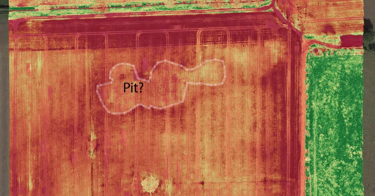
The final resting place of thousands of Royalist soldiers killed in the English Civil War may have been revealed using new drone technology.
Amateur archaeologist Tony Hunt found the mass graves at White Sike Close, near the A59 between Harrogate and York, using drones equipped with infrared and thermal imaging cameras.
He said:
The soldiers were killed making a last stand at the Battle of Marston Moor, which was fought on July 2, 1644. The battle was the largest of the English Civil War, and the Parliamentarians' victory effectively ended Royalist influence in the North of England. King Charles I was beheaded less than five years later.
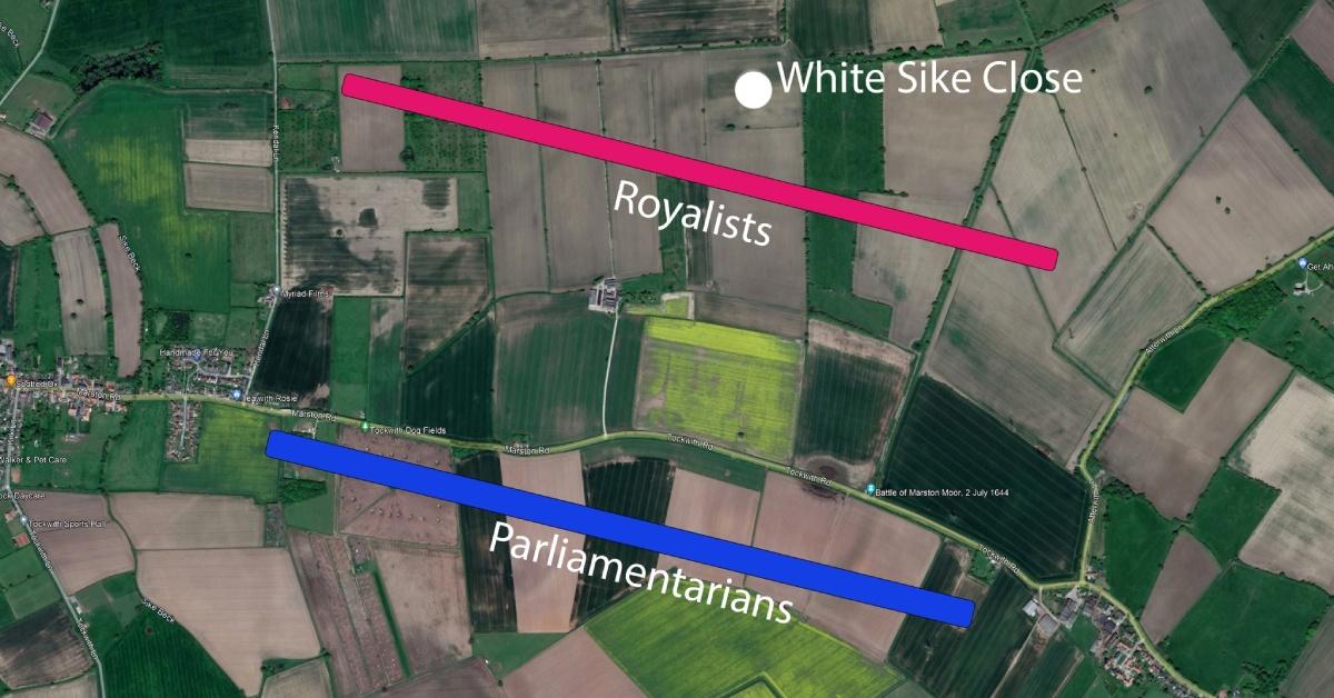
Satellite map with battle lines overlaid showing the disposition of forces at the Battle of Marston Moor in 1644.
Estimates of casualties vary, but it is believed that at least 300 Parliamentarians and 4,000 Royalists were killed at the battle.
The battlefield site, which is registered on the National Heritage List for England, lies within the boundaries of the Harrogate district.
Chris Rock, Yorkshire regional chair of the Battlefields Trust, said:
But Mr Hunt says he doesn’t want to investigate further. He said:

Detail of a 19th-century map, showing the location of White Sike Close, where Royalist soldiers are believed to have made a last stand - and been buried.
The English Civil Wars were fought between 1642 and 1652 and pitted King Charles I and his Royalists against the Parliamentarians, led by Oliver Cromwell, who generally believed in the primacy of Parliament over the monarch. It resulted in the execution of the king and the establishment of the Commonwealth of England.
Mr Hunt has a degree in archaeological sciences from Bradford University and is currently managing director of DJ Assembly, a York-based micro-electronics company. He also runs Yorkshire Aerial Archaeological Mapping, whose thermal and infrared imaging technology revealed the burial pits.
He has previously used his drone technology to locate many other sites of historic interest. Last summer, he found a missing section of Roman road, and early this year he discovered a suspected prehistoric henge under the village of Kirk Hammerton.
Read more:
- New Harrogate district henge could be 'nationally significant'
- Missing section of main Roman road found at Green Hammerton
- Calls for archeological survey into Knaresborough's Roman past
0